 ;
;

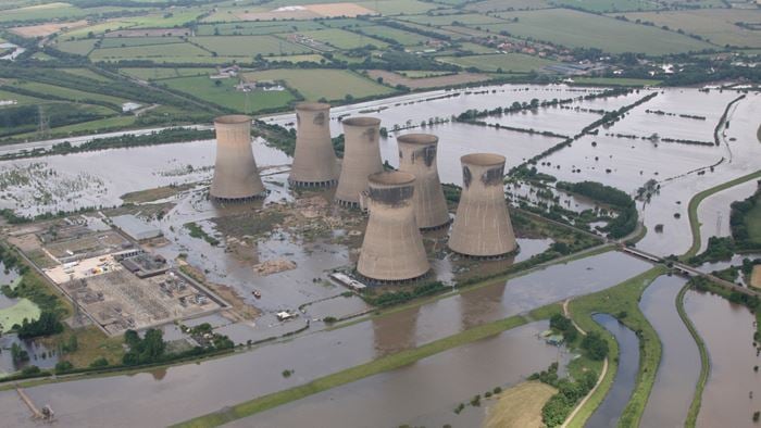
Running along 500 miles of the San Francisco Bay’s shoreline, the Bay Trail spans 47 cities and nine counties, acting as the backbone of the region’s trail network while also creating important connections for recreation and active transportation. Additionally, many sections of the trail also run along the top of coastal levees, providing de facto flood protection for neighboring communities and adjacent infrastructure. However, with the acceleration of sea level rise, this valued resource faces increasing risk of major flooding and progressive erosion.
In response to the threat of climate change, the East Bay Regional Park District recognized a dire need to start planning and coordination with partners and key stakeholders for the immediate and long-term resilience of the cherished trail to ensure continued shoreline access for the community. Playing a key role in the San Francisco Bay Trail Risk Assessment and Adaptation Prioritization Plan (RAAPP), Arup was part of an interdisciplinary team led by WRT that included Environmental Science Associates (ESA), the San Francisco Estuary Institute (SFEI), and OnClimate. Focusing on a 55-mile segment of the 500-mile trail, Arup provided hazard, vulnerability and consequence analyses, risk assessment, and adaptation prioritization services which were used to develop a method and model for innovative natural and nature-based interventions on the Bay Trail.
Project Summary
55mi of trail along the Alameda and Contra Costa County shoreline
8trail sites analyzed
1multi-criteria risk assessment matrix
Protecting a community resource from climate change
With many coastal municipalities working to both address and predict the effect of rising sea levels, the RAAPP was developed to establish clear planning horizons that chart projected sea level rise scenarios while also offering critical planning for future impacts and initiating stakeholder collaboration across the dozens of cities the Bay Trail serves.
Making this assessment even more urgent, the East Bay’s complex shoreline puts the trail at a distinctively higher risk to the impacts of flooding. Many of the Bay Area communities it serves are those most disproportionately affected by climate change, and a large proportion of commuters who take regional public transit rely on the Bay Trail to get to work and schools. Any impact on the trail’s critical infrastructure would negatively impact employment, housing, and access to educational opportunities. When evaluating the consequences of flooding along each segment of the Bay Trail, Arup considered social equity, the economy, the environment, and access to public transit.
These insights helped us develop an equity-weighted risk matrix approach comprised of quantitative metrics and site-specific priorities to ensure that adaptation strategies did not disproportionately advantage wealthier communities. Arup’s risk matrix also accounted for the present value of future damages and impacts that climate change could have on the trail and neighboring communities based on several sea level rise scenarios.
© WRT
Analyzing risk to create resilience
As the leading partner of the Bay Trail risk assessment, Arup developed an equity-weighted risk matrix that identified priority-trail segments and sites for adaptation using a simple formula: risk = hazard x vulnerability x consequence.
With this framework, we gathered data from eight priority sites located across all points of the Bay Trail. When analyzing each site through the risk matrix formula, we prioritized hazard elements like tidal inundation and extreme wave conditions, vulnerability to erosion and damage from a severe flood event, and the consequences that could result from sea level rise and coastal flooding.
The data gathered from this assessment yielded a range of data-driven conclusions including trail repair costs, ecosystem services, and recreational value for each of the priority segments. The metrics also revealed which segments were most in harm’s way from future flooding.
“The Bay Trail RAAPP helps our clients prioritize projects and come up with adaptation concepts. The Park District now has a shortlist of projects to work on when planning for sea level rise, as well as concepts developed by our team, to help inform future work that will better prepare the Bay Trail for the effects of coastal flooding. ”
Jack Hogan Senior Climate Change Risk and Resilience Engineer

Harnessing data to model resilience
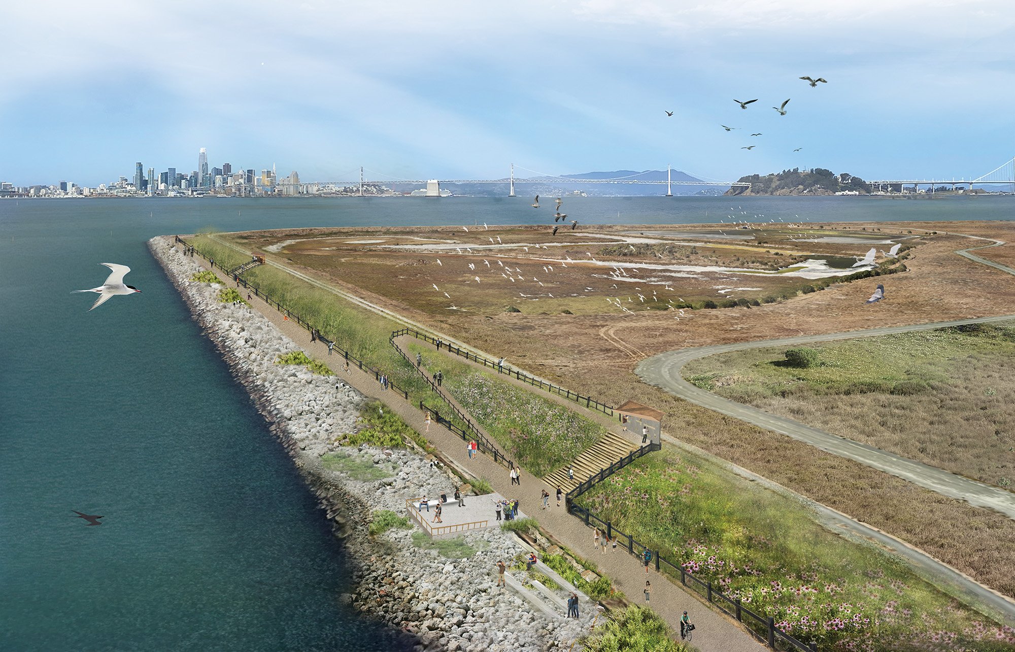
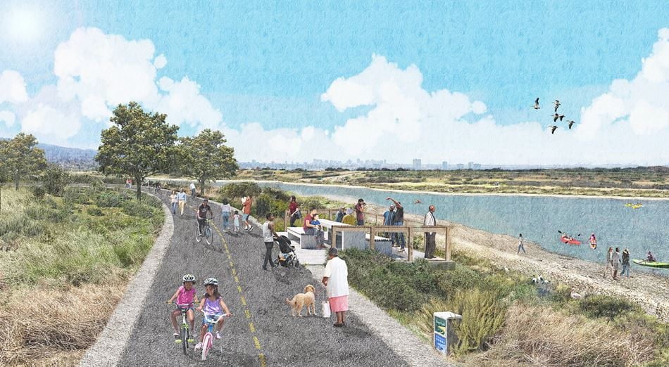
With actionable insights from the Arup-led risk assessment, our partners used the matrix as a decision-support tool to identify two Bay Trail sites as prototypes for nature-based shoreline adaptation projects: Alameda Point and McLaughlin Eastshore State Park. Design concepts for each site were developed and informed by unique local ecological conditions and opportunities to maximize public access to the shoreline and restoration opportunities through nature-based solutions. Consideration was given to address long-term contamination mitigation and stakeholder collaboration at local, regional, and federal levels.
As many cities in California look to develop coastal resilience and climate adaption plans, stakeholder collaboration along with innovative approaches to analysis and design can provide pathways for a sustainable future.
All images provided courtesy of WRT.
Related
Projects